The summer of 2025 brought
unprecedented flash flooding across the U.S., with the central and eastern regions hit particularly hard. These storms claimed
hundreds of lives across Texas,
Kentucky, and several other states and caused widespread destruction.
At the same time, every hurricane that formed, including the three powerful Category 5 storms, steered clear of the U.S. mainland.
Both scenarios were unusual – and they were largely directed by the polar jet stream.
Related: A secret weapon for fighting climate change comes surging back.
What is a jet stream?
Jet streams are narrow bands of high-speed winds in the upper troposphere, around four to eight miles (seven to 13 kilometers) above the surface of the Earth, flowing west to east around the entire planet. They form where strong temperature contrasts exist.
Each hemisphere hosts two primary jet streams:
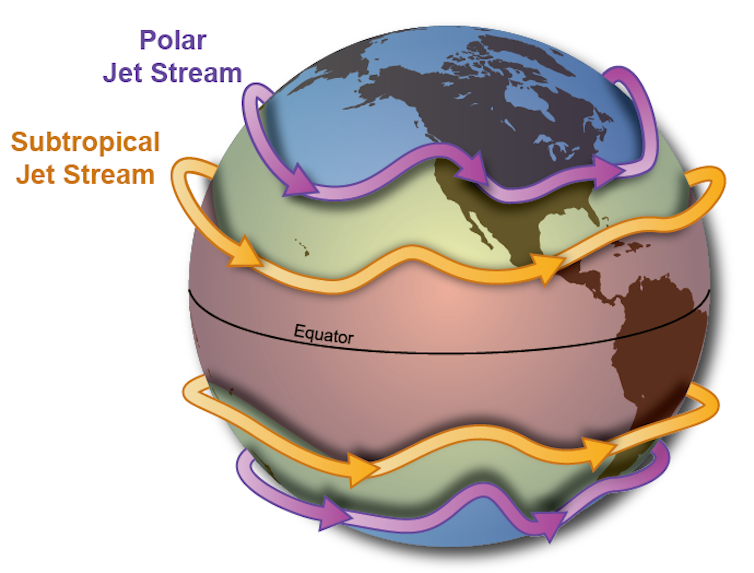 The polar and subtropical jet streams are in positions similar to those of much of summer 2025. NOAA
*****
What does the jet stream do in Apopka?
In Apopka, shifts in the polar and subtropical jet streams can directly influence everything from heavy rainfall to extended heat and drought. When the jet stream weakens or stalls over Central Florida, slow-moving storm systems can lead to prolonged downpours, increasing the risk of localized flooding along creeks, low-lying neighborhoods, and roadways, particularly during the summer rainy season. Conversely, when the jet stream shifts north or becomes locked in place elsewhere, Apopka may experience longer stretches of heat, limited rainfall, and added stress on water resources—illustrating how large-scale atmospheric patterns can have very real, local impacts on daily life in Apopka.
*****
The polar jet stream is typically found near 50 to 60 degrees latitude, across Canada in the Northern Hemisphere, where cold polar air meets warmer midlatitude air. It plays a major role in modulating weather systems in the midlatitudes, including the continental U.S. With winds up to 200 mph, it’s also the usual steering force that brings those bitter cold storms down from Canada.
The subtropical jet stream is typically closer to 30 degrees latitude, which in the Northern Hemisphere crosses Florida. It follows the boundary between tropical air masses and subtropical air masses. It’s generally the weaker and steadier of the two jet streams.
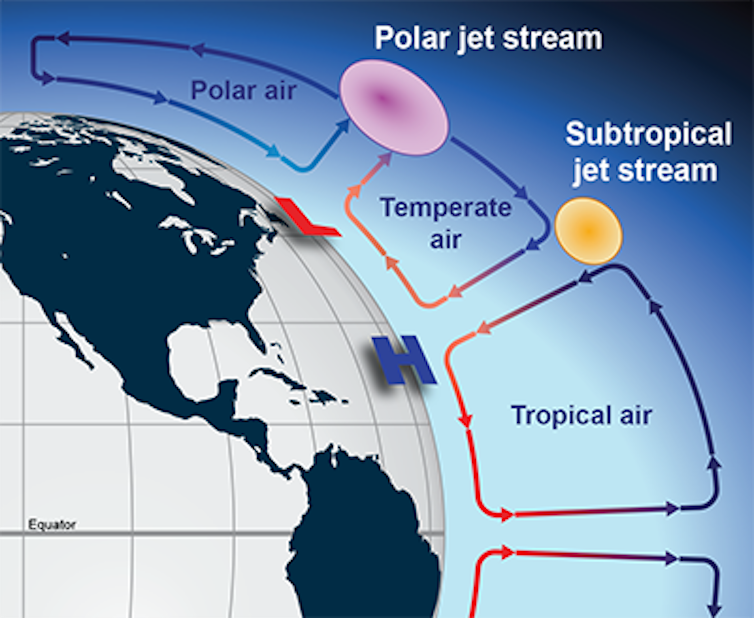 A cross section of atmospheric circulations shows where the jet streams exist between large cells of rising and falling air, movements largely driven by solar heating in the tropics. NOAA
These jet streams act like atmospheric conveyor belts, steering storm systems across continents.
Stronger (faster) jet streams can intensify storm systems, whereas weaker (slower) jet streams can stall storm systems, leading to prolonged rainfall and flooding.
2025’s intense summer of flooding
Most summers, the polar jet stream retreats northward into Canada and weakens considerably, leaving the continental U.S. with calmer weather. When rainstorms pop up, they’re typically caused by localized convection due to uneven heating of the land – picture afternoon pop-up thunderstorms.
During the summer of 2025, however, the polar jet stream shifted unusually far south and steered larger storm systems into the midlatitudes of the U.S. At the same time, the jet stream weakened, with two critical consequences.
First, instead of moving storms quickly eastward, the sluggish jet stream stalled storm systems in place, causing prolonged downpours and flash flooding.
Second, a weak jet stream tends to meander more dramatically. Its broad north-south swings in summer 2025 funneled humid air from the Gulf of Mexico deep into the interior, supplying storm systems with abundant moisture and intensifying rainfall.
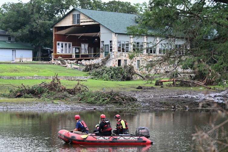 Search-and-rescue crews look for survivors in Texas Hill Country after a devastating July 4, 2025, flash flood on the Guadalupe River swept through a girls’ camp, tearing walls off buildings. Ronaldo Schemidt/AFP via Getty Images
This moisture surge was amplified by unusually warm conditions over the Atlantic and Gulf regions. A warmer ocean evaporates more water, and warmer air holds a greater amount of moisture. As a result, extraordinary levels of atmospheric moisture were directed into storm systems, fueling stronger convection and heavier precipitation.
Finally, the wavy jet stream became locked in place by persistent high-pressure systems, anchoring storm tracks over the same regions. This led to repeated episodes of heavy rainfall and catastrophic flooding across much of the continental U.S. The same behavior can leave other regions facing days of unrelenting heat waves.
The jet stream buffered US in hurricane season
The jet stream also played a role in the 2025 hurricane season.
Given its west-to-east wind direction, the southward dip of the jet stream – along with a weak high pressure system over the Atlantic – helped steer all five hurricanes away from the U.S. mainland.
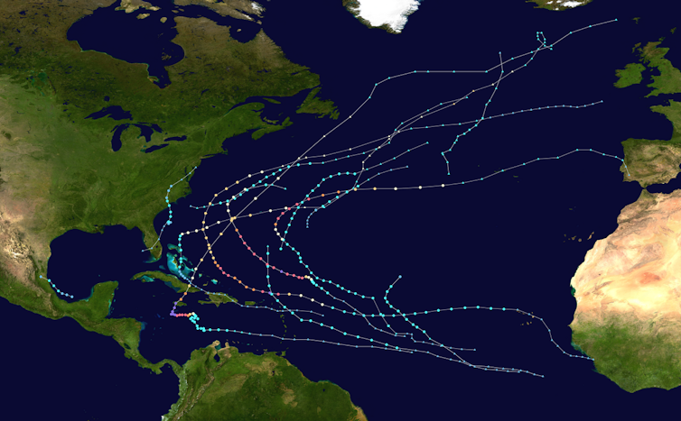 The 2025 Atlantic hurricane season’s storm tracks show how most of the storms steered clear of the U.S. mainland and veered off into the Atlantic. Sandy14156/Wikimedia Commons
Most of the year’s 13 tropical storms and hurricanes veered off into the Atlantic before even reaching the Caribbean.
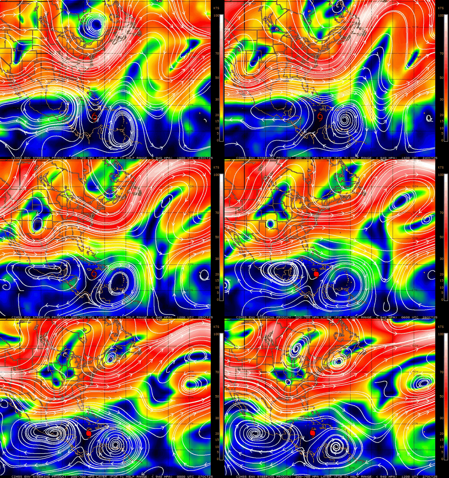 Charts of high-level steering currents over five days, Oct. 23-27, 2025, show the influences that kept Hurricane Melissa (red dot) in place for several days. The strong curving winds in red are the jet stream, which would help steer Melissa northeastward toward the open Atlantic. Cooperative Institute for Meteorological Satellite Studies/University of Wisconsin-Madison, CC BY-ND
Climate change plays a role in these shifts
So, how does climate change influence the jet stream?
The strength of jet streams is controlled by the temperature contrast between the equatorial and polar regions.
A higher temperature contrast leads to stronger jet streams. As the planet warms, the Arctic is heating up at more than twice the global average rate, and that is reducing the equator-to-pole temperature difference. As that temperature gradient weakens, jet streams lose their strength and become more prone to stalling.
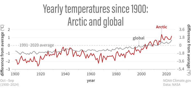 The Arctic has been warming two times faster than the planetary average. NOAA Arctic Report Card 2024
This increases the risk of persistent extreme rainfall events.
Weaker jet streams also meander more, producing larger waves and more erratic behavior. This increases the likelihood of unusual shifts, such as the southward swing of the jet stream in the summer of 2025.
A recent study found that amplified planetary waves in the jet streams, which can cause weather systems to stay in place for days or weeks, are occurring three times more frequently than in the 1950s.
As the global climate continues to warm, extreme weather events driven by erratic behavior of jet streams are expected to become more common. Combined with additional moisture that warmer oceans and air masses supply, these events will intensify, producing storms that are more frequent and more destructive to societies and ecosystems.
In the short term, the polar jet stream will be shaping the winter ahead. It is most powerful in winter, when it dips southward into the central and even southern U.S., driving frequent storm systems, blizzards, and cold air outbreaks.
Key Points
- The polar jet stream shifted farther south than usual in summer 2025 and weakened significantly.
-
Slower jet stream winds caused storm systems to stall, leading to prolonged rainfall and flash flooding.
-
Warm Atlantic and Gulf waters increased atmospheric moisture, further intensifying storms.
-
The jet stream’s position also helped divert hurricanes away from the U.S. mainland.
-
Climate change is weakening the temperature gradient that drives jet streams, increasing the likelihood of extreme and persistent weather events.
This article is republished from The Conversation under a Creative Commons license.