Hurricane Idalia is still intensifying over the Gulf of Mexico, headed for a Florida Gulf Coast landfall Wednesday with catastrophic, life-threatening storm surge, hurricane-force winds and flooding rain.
Parts of south Georgia and the Carolinas will also see significant impacts from Idalia, including damaging winds, flooding rain and tornadoes.
If you live in an area prone to storm surge, be sure to follow the advice of local officials if evacuations are ordered. The latest on evacuations for Idalia can be found here.
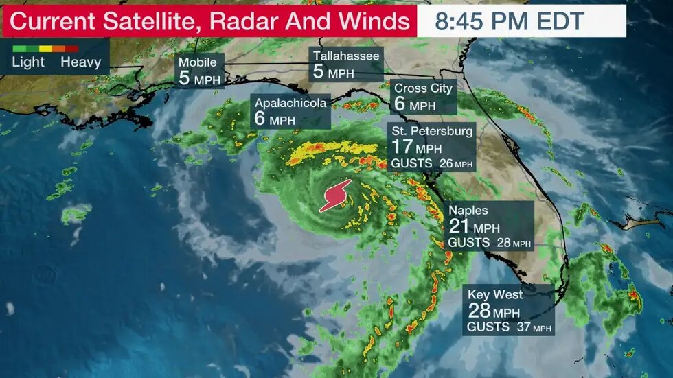
Here's where Idalia is now and where it's headed next: The center of the storm is over the southern Gulf of Mexico about 245 miles south of Tallahassee. Maximum sustained winds have increased to 105 mph as of 8 p.m. EDT.
Outer bands of rain containing gusty winds continue to pivot into much of Florida. Several locations in south and southwest Florida have clocked wind gusts over 40 mph, and a few locations have topped 50 mph gusts in those rainbands.
Water levels were about 1 to 2 feet above normal from Naples to Fort Myers and the Tampa Bay area with the midday high tide. Some low-lying areas have seen inundation from this coastal flooding.
 Idalia should move northward through the Gulf of Mexico and then turn northeast toward Florida Wednesday morning.
Plenty of warm water and favorable upper-level winds will make rapid intensification possible. Idalia is forecast to be at Category 3 strength when it makes landfall Wednesday morning in Florida's Big Bend region.
After that, it will track over south Georgia and the coastal Carolinas through Thursday while eventually weakening to a tropical storm.
Major impacts from Idalia will extend outside the forecast path shown below, including the Tampa Bay area.
 Hurricane and tropical storm alerts: A hurricane warning is in effect for the areas shaded in purple in the map below. That includes Tampa-St. Petersburg, Gainesville, Tallahassee and parts of southern Georgia. A hurricane warning means that hurricane conditions (74+ mph winds) are expected somewhere in this area within 24 hours.
Hurricane watches, tropical storm watches and tropical storm warnings have been issued for many other parts of Florida into south Georgia and the Carolinas, as shown in the map below.
 Watches And Warnings
The National Weather Service in Tallahassee noted in their Tuesday morning discussion, "Widespread deep inundation with storm surge flooding will be greatly accentuated by powerful battering waves. Locations may be uninhabitable for an extended period of time. Near-shore escape routes and secondary roads may be washed out or severely flooded."
A storm surge warning is in effect for Englewood to Indian Pass, including Tampa Bay. This means there is a danger of life-threatening inundation from rising water moving inland from the shoreline within the specified area.
Storm surge watches and warnings are in effect for other parts of the Florida coast to southeast Georgia, South Carolina and North Carolina.
-Aucilla River, Florida, to Yankeetown, Florida: 10-15 feet
-Yankeetown to Chassahowitzka, Florida: 7-11 feet
-Ochlockonee River, Florida, to Aucilla River, Florida: 7-11 feet
-Chassahowitzka, Florida, to Anclote River, Florida: 6-9 feet
-Anclote River, Florida, to middle of Longboat Key, Florida: 4-6 feet
-Tampa Bay: 4-6 feet
-Carrabelle, Florida, to Ochlockonee, Florida: 4-7 feet
 Storm Surge Forecast
Parts of the west coast of Florida, the Florida Panhandle, southeast Georgia and the eastern Carolinas may receive 4 to 8 inches of rainfall, with isolated higher amounts of 12 inches possible, primarily near landfall in northern Florida, according to the National Hurricane Center.
Rainfall Forecast
Elsewhere, at least scattered power outages and some tree damage can be expected from other parts of Florida to the coastal Carolinas.
Tropical storm force winds will reach areas of Florida in the hurricane warning soon, and hurricane force winds are expected to begin later tonight or early Wednesday.
These hurricane force winds may extend into southern Georgia, due to how fast the hurricane is moving and its intensity at landfall.
Tropical storm conditions are expected to begin Wednesday in the warning area along the east coast of Florida, Georgia and South Carolina. Tropical storm conditions are possible within the watch area in North and South Carolina by Thursday.
 Tornadoes are also a threat midweek. A few tornadoes may develop in rainbands ahead of Idalia along the west-central Florida coast and will spread into the Big Bend area into Wednesday morning.
The threat for a few tornadoes may persist across parts of northern Florida Wednesday morning and will spread along the Southeast coast later Wednesday.


