
- Tropical Storm Idalia has developed near the Yucatan Peninsula.
- After lingering near Cancun, it will move north into the Gulf of Mexico.
- Idalia is forecast to become a hurricane before making landfall along Florida's Gulf Coast by Wednesday.
- Flooding rain, strong winds, high surf, coastal flooding and some tornadoes are possible.
- It will spread heavy rain and winds into parts of the Southeast.
Tropical Storm Idalia is organizing and has developed in the Caribbean Sea, near the Yucatan Peninsula. Idalia is forecast to strengthen early this week as it moves northward through the Gulf of Mexico.
It is expected to make landfall in Florida as a hurricane with heavy rain, storm surge flooding, and high winds midweek.
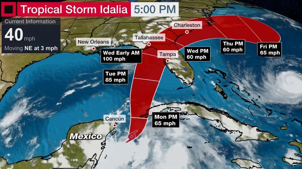
What is the latest on Idalia? The system was named Tropical Depression Ten late Saturday afternoon and strengthened into Tropical Storm Idalia late Sunday morning.
It is moving slowly near Cancún and will remain in the area until Monday. Heavy rain extends from Mexico's Yucatan Peninsula to western Cuba.
A tropical storm warning is in effect for western Cuba's Pinar del Rio, while a watch is in effect for the Isle of Youth, where tropical storm conditions are possible.
Current Storm Status And Forecast Path
What is its future in the Gulf? The latest data suggest Idalia should finally begin moving north by either late Monday or early Tuesday.
On that track, its center could arrive somewhere along Florida's Gulf Coast on Wednesday. After that, most computer models suggest it would take a bend, tracking through Georgia and the Carolinas through Thursday or early Friday.
 Computer Model Forecast Tracks
All other factors equal warmer water can provide more fuel for a tropical storm or hurricane to intensify.
Furthermore, recent computer models suggest wind shear during its northward journey toward Florida may be lower than previously forecast. Wind shear is usually a hostile factor that can weaken or slow a storm's intensification.
Therefore, the National Hurricane Center is forecasting Idalia to become a Category 1 hurricane, possibly stronger, before its Florida landfall. The National Hurricane Center also noted in its Sunday morning discussion that "There's a notable risk of rapid intensification while the system moves across the record warm eastern and northeastern Gulf of Mexico."
 Forecast Path And Ocean Heat Content
Heavier rain appears to begin sometime Tuesday, continuing into Thursday from Florida into parts of Alabama, Georgia, and the Carolinas. That will likely trigger local flash flooding in some areas.
Three to six inches of rainfall, with totals up to 10 inches, are possible for parts of the west coast of Florida, the Florida Panhandle, and southern Georgia from Tuesday into Wednesday, according to the National Hurricane Center.
Any damaging wind or coastal flooding/storm surge impacts will depend on Idalia's strength and track, but those are uncertain factors this far out. That said, Florida's Gulf Coast is very prone to storm surge, even for modest hurricanes and tropical storms.
Rainfall Forecast
The best course of action for now is to stay up to date on the latest forecast changes and review and ready your hurricane preparation plans.


