From weather.com
At a Glance
Hurricane Dorian is now moving through the western Atlantic Ocean.
A hurricane watch has been issued for the northwestern Bahamas.
Dorian will threaten parts of the Bahamas and the southeastern U.S. over Labor Day weekend.
The most likely scenario is a track near the Florida Peninsula late in the weekend, but exact details will change.
Residents from the northern Gulf Coast to Florida, Georgia and the Carolinas should monitor forecasts closely.
Dorian is a Category 2 hurricane and is forecast to intensify into a powerful Category 4, posing a prolonged danger that may last days to Florida and the southeastern United States over Labor Day weekend.
Dorian's center is about 255 miles east-northeast of the southeastern Bahamas, with maximum sustained winds of 105 mph.
Current Storm Status
(The highest cloud tops, corresponding to the most vigorous convection, are shown in the brightest red colors. Clustering, deep convection around the center is a sign of a healthy tropical cyclone.)
A hurricane watch has been issued for the northwestern Bahamas.
A hurricane watch means that hurricane conditions are possible within the watch within 48 hours.
Watch, Warnings
(A watch is issued when tropical storm or hurricane conditions are possible within 48 hours. A warning is issued when those conditions are expected within 36 hours.)
Below is the latest on Dorian's timing and what we know about potential forecast impacts right now.
Through Friday: Dorian's center is expected to track to the north and east of the Turks and Caicos and the southeastern Bahamas. Dorian will strengthen and will likely become a major hurricane (Category 3 or higher) later Friday.
Saturday: Dorian will bend west-northwest to west by early Saturday and it is expected to slow its forward motion. Dorian will likely begin to impact the northwestern Bahamas by Saturday night or early Sunday.
Sunday-Monday: Dorian will continue to slow down as it approaches and begins to impact the southeastern U.S., most likely somewhere between Florida and southeastern Georgia. That said, areas as far north as the Carolinas should also monitor for potential impacts from Dorian early next week.
Tuesday-Wednesday: Dorian's slow movement could allow it to continue impacting the Florida Peninsula and possibly other parts of the Southeast into the middle part of next week.
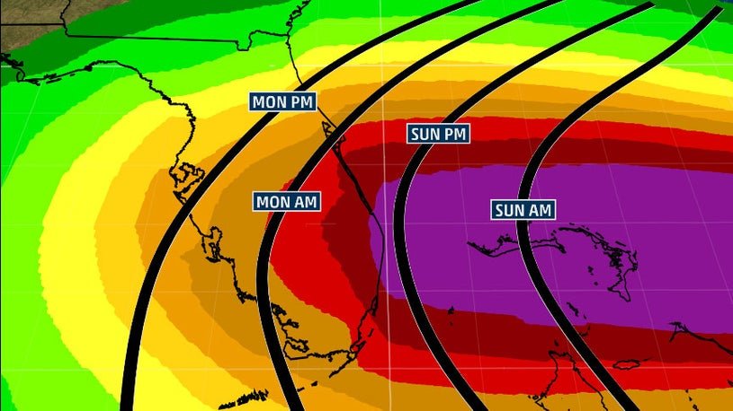
Projected Path
(The red-shaded area denotes the potential path of the center of Dorian. It's important to note that impacts – heavy rain, high surf, coastal flooding and winds – with any tropical cyclone usually spread beyond its forecast path.)
Uncertainty continues to be high when it comes to exact forecast impacts in the southeastern U.S. However, all interests in the Bahamas, the northern Gulf Coast, Florida, Georgia and the Carolinas should have their hurricane plans ready and monitor the forecast of Dorian closely.
High pressure aloft will steer Dorian westward toward Florida this weekend. A turn to the north is then expected as the western periphery of the high is eroded by a disturbance moving through the eastern United States. Where that northerly turn occurs is uncertain.
Among the myriad track possibilities are a track farther north toward the southeastern Georgia coast and the Carolinas or one slicing across the Florida Peninsula, then emerging into the Gulf of Mexico and potentially threatening parts of the northern Gulf Coast next week.
The uncertainty in Dorian's exact track is mainly related to an area of high pressure off the East Coast. If high pressure remains relatively strong over the Southeast, then Dorian would track straight into Florida. But if the western periphery of the high is significantly eroded by a subtle disturbance moving through the eastern United States, then Dorian could turn more northward near the coast of Florida.
Regardless of its exact track, Dorian is likely to be a dangerous hurricane – potentially a Category 4 – when it approaches Florida later this weekend or early next week.
In the northwestern Bahamas, the risk of life-threatening storm surge and hurricane-force winds this weekend continues to increase. Rainfall totals of 6 to 12 inches are expected, with isolated amounts of 15 inches in the northwestern Bahamas, which may cause flash flooding, according to the National Hurricane Center. The central Bahamas can expect 1 to 2 inches, with isolated totals up to 4 inches.
Storm surge may cause water levels to be as much as 10 to 15 feet above normal tide level in areas of onshore winds in the northwestern Bahamas.
It's too early to know the exact magnitude and location of any impacts from damaging winds, storm surge or flooding rainfall at this time in Florida and the rest of the Southeast. However, there is an increasing likelihood of a prolonged period of hazardous weather conditions that could last a couple of days in parts of Florida early next week.
"The biggest concern will be Dorian's slow motion when it is near Florida, placing some areas of the state at an increasing risk of a prolonged, drawn-out event of strong winds, dangerous storm surge, and heavy rainfall," the National Hurricane Center said early Friday.
(MAS: Dorian en Español)
Regardless of Dorian's exact track, coastal sections of the Southeast could see at least 6 to 12 inches (locally, 15 inches) of rain, according to the National Hurricane Center. Dorian's slower movement as it nears the coast could cause major flooding.
Rainfall Outlook
(This should be interpreted as a broad outlook of where the heaviest rain may fall. Higher amounts may occur where bands or clusters of thunderstorms stall for over a period of a few hours.)
Destructive winds and life-threatening storm-surge flooding will likely impact the east coast of Florida or some other part of the Southeast late this weekend into early next week, but it's too early to nail down where the worst impacts will be felt.
In addition, the highest high tides of the year, known as "king tides," are expected this weekend in parts of Florida. King tides occur several times a year, and when combined with a major weather system, the floodwater inundation can be much more significant.
If you live in an area prone to storm surge, be sure to follow the advice of local officials if evacuations are ordered.
Chance and Likely Timing of Tropical Storm Force Winds
(Winds of at least 39 mph)
Check back with weather.com for the latest on Hurricane Dorian.


Comments
No comments on this item Please log in to comment by clicking here