from weather.com
Tropical Storm Emily moved ashore along central Florida's Gulf Coast Monday morning. It will quickly move inland over Florida today, then into the Atlantic waters off Florida on Tuesday. Heavy rain and flash flooding are the main threats.
Emily developed from a small area of low pressure along a washed-out front.
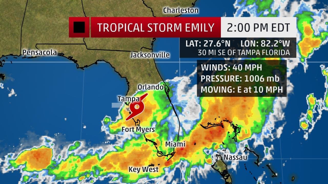
Tropical Storm Emily has made landfall along Florida's Gulf Coast in the Tampa/St. Petersburg metro area, and is already wringing out flooding rain over parts of the Florida peninsula.
(MORE: Hurricane Central)
The center of Emily moved ashore at 10:45 a.m. EDT on Anna Maria Island, near Bradenton, with estimated maximum sustained winds of 45 mph.
Current Storm Information
The highest cloud tops, corresponding to the most vigorous convection, are shown in the brightest red colors. Clustering, deep convection around the center is a sign of a healthy tropical cyclone.
Earlier Monday morning, the National Hurricane Center initiated advisories on Tropical Depression Six. Two hours later, Doppler radar suggested the tiny circulation had developed winds strong enough to merit an upgrade to Emily, the fifth named storm of the 2017 Atlantic hurricane season.
Tropical storm warnings continue for the majority of the Tampa/St. Petersburg metro area from Pinellas County southward to Lee County.
(MORE: Where and When the Season's First Atlantic Hurricane Forms)
Alerts
A watch is issued when tropical storm or hurricane conditions are possible within 48 hours. A warning is issued when those conditions are expected within 36 hours.
Winds damaged the roof of a mobile home south of Bradenton late Monday morning. Gusts close to 60 mph prompted closure of the Sunshine Skyway Bridge linking St. Petersburg to Manatee County.
Two areas of heavy rain had already pushed into parts of central and South Florida, one closer to the center of Emily, another extending from south of Fort Myers to parts of the Atlantic beaches.
(INTERACTIVE: Your Local Radar Loop)
Current Radar, Satellite, Watches and Warnings
Watches and warnings are issued by the National Weather Service.
A spotter in Hillsborough County near Valrico measured over 8 inches of rain, so far as of just before 1 p.m. EDT. Street flooding prompted a closure of a stretch of Ninth Street, according to the spotter.
The threat of heavy rain isn't a function of how strong a tropical cyclone is, but rather how slowly it moves.
Emily will cross the Florida Peninsula and exit into the Atlantic well north of the northwest Bahamas by early Tuesday.
Projected Path
The red-shaded area denotes the potential path of the center of the tropical cyclone. Note that impacts (particularly heavy rain, high surf, coastal flooding) with any tropical cyclone may spread beyond its forecast path.
Areas along and to the south of the track of Emily, a swath across parts of central and South Florida, have the best chance of seeing heavy rain.
(MORE: Your Vehicle Can Be Deadly in a Flash Flood)
Additional Rainfall Forecast
Locally higher rain totals are possible where heavy rainbands stall for a period of a few hours.
While soil moisture isn't anomalously high for this time of year, rain rates of 1 to 3 inches per hour are possible in the heaviest rainbands, capable of triggering flash flooding or, at the very least, widespread ponding of water on roads.
This is obviously a more widespread threat of heavy rain than you see on a typical afternoon of scattered thunderstorms in Florida's wet season.
This will add to what's been a rather wet summer in parts of the Sunshine State. According to the Southeast Regional Climate Center, Gainesville and Naples, Florida, have each had their record-wettest summers (since June 1) to date through July 29.
Little strengthening is expected once the system is over the Atlantic Ocean, and it should remain off the rest of the East Coast and not have any impacts beyond Florida.
Twitter follower BeasleyParker probably summed up the feelings of many upon hearing the news early Monday.
Most landfalling tropical cyclones come with at least 24 hours advance warning, usually more.
This all started with a cold front that dropped south into the northern Gulf of Mexico during the weekend, then stalled out.
You don't typically see cold fronts penetrate that far south this deep in the summer. The end of July is typically hazy, hot and humid in the Southeast U.S., not featuring strangely comfortable air masses plunging from Canada into the Deep South.
(MORE: 7 Odd Things We Saw in the Weather in Late July)
Early in the hurricane season, these old fronts are typically monitored closely for tropical development.
Ripples of low pressure can form along these stationary fronts and, if thunderstorms cluster near those surface low-pressure ripples, a tropical depression or storm can quickly form.
In Emily's case, a swirl of low pressure was evident on radar and satellite imagery Sunday morning about 100 miles south of Pensacola, Florida.
Sunday night, thunderstorms near the circulation became more vigorous and concentrated, with several cloud-to-ground lightning strikes documented, as it moved east-southeast.
Radar, satellite, cloud-to-ground lightning history of what became Tropical Storm Emily in the Gulf of Mexico from July 30-31, 2017. (Lightning Data: Vaisala)
By Monday morning, utilizing Doppler radar from the National Weather Service office in Ruskin, Florida, forecasters at the National Hurricane Center determined this previous ripple of low pressure had enough persistent showers and thunderstorms with strong enough winds to name it Tropical Depression Six.
Just two hours later, Doppler velocity data indicated winds had ticked upward enough to bump the system to Tropical Storm Emily.
The poster child recent "developing quickly" tropical system in the Gulf happened almost 10 years ago, once again, involving an old frontal boundary.
On September 12, 2007, a system went from a Tropical Depression just over 100 miles south of Galveston, Texas, to Category 1 landfalling Hurricane Humberto less than 24 hours later.
Because Humberto formed and intensified so rapidly, warnings were issued with far less lead time than usual. Tropical storm warnings were issued 16 hours before landfall, but hurricane warnings came only two hours before landfall.
Humberto was a classic example of how difficult it can be for forecasters to anticipate rapid strengthening and issue appropriate alerts to the public.
Despite the short warning, Humberto's impact was limited to one death and about $50 million in damage, striking a sparsely-populated area of the coast east of Houston.


Comments
No comments on this item Please log in to comment by clicking here