From the Weather Channel
Hurricane Irma is now on a course for the Turks and Caicos and the Bahamas as a Category 5 hurricane.
Hurricane warnings have been issued for portions of the Greater Antilles and the Bahamas.
Irma is increasingly likely to target parts of the Florida peninsula as a dangerous hurricane this weekend.
Parts of Georgia and the Carolinas could then be struck by Irma early next week.
Hurricane Irma, a potentially catastrophic Category 5 hurricane, is tracking north of the Domincan Republic this morning and will then head for the Turks and Caicos and the Bahamas, before posing a serious threat to Florida and parts of the Southeast beginning this weekend.
(MORE: Hurricane Central | Impacts In Caribbean)
Below is everything we know about Irma right now, including its latest status, along with potential forecast impacts in the U.S. and the Caribbean Islands.
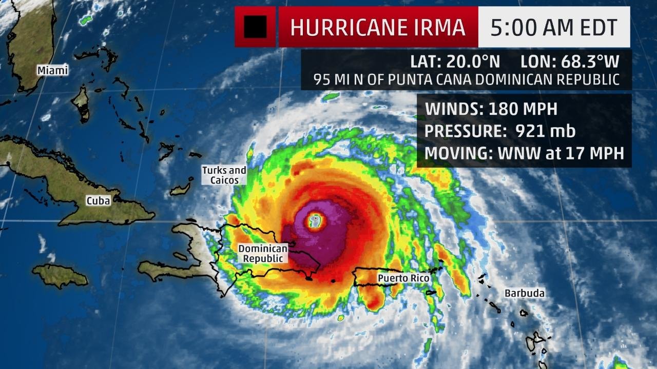
The center of Irma is located about 210 miles east-southeast of Grand Turk Island and is moving west-northwestward at about 17 mph.
Irma's maximum sustained winds are at 180 mph based on data from NOAA and Air Force Hurricane Hunter aircraft, after being steady at 185 mph for an astounding 35 hours.
(MORE: Irma's Notable Extremes)
Irma will track just north of the Dominican Republic and Haiti on Thursday and will be near the Turks and Caicos and southeastern Bahamas by Thursday evening.
Current Storm Status
The highest cloud tops, corresponding to the most vigorous convection, are shown in the brightest red colors. Clustering, deep convection around the center is a sign of a healthy tropical cyclone.
Hurricane warnings have been issued for parts of the northern coast of the Dominican Republic and Haiti, the southeastern, central and northwestern Bahamas and the Turks and Caicos Islands.
Additionally, a tropical storm warning is in effect for the southern coast of the Dominican Republic from Cabo Engano westward to the border with Haiti and for the coast of Haiti from south of Le Mole St. Nicholas to Port-Au-Prince. A tropical storm warning is also in effect for the Cuban provinces of Guantanamo, Holguin and Las Tunas.
A hurricane watch is also in effect Cuba from Matanzas Province eastward to Guantanamo Province and the northwestern Bahamas.
Watches and Warnings
A watch means hurricane or tropical storm conditions are possible within 48 hours. A warning means those conditions are expected within 36 hours.
Low wind shear, increased mid-level moisture and increasing oceanic-heat content favor that Irma will remain a powerful hurricane (Category 4 or stronger) for the next several days, though some intensity fluctuations are likely at times. At this intensity, small deviations in wind speed will not change impacts. A direct hit will be catastrophic.
The mountainous terrain of Hispañola could be enough to slightly disrupt the circulation of Irma, allowing winds to drop some, but not by much.
Given the robust nature of Irma's structure, it is possible that it will retain strength longer than currently expected, potentially into the Florida Straights as a Category 5.
Irma has been a Category 5 hurricane for more than a day and a half, which ranks it as the 7th longest lasting Category 5 in the Atlantic basin, according to Dr. Phil Klotzbach. Irma could take a run at the longest lasting Category 5 hurricane by Friday.
For the next three days, Irma will move west-northwest on the south side of a ridge of high pressure called the Bermuda high, centered in the central Atlantic.
(INTERACTIVE MAP: Track Irma)
By this weekend, Irma will begin to turn north in the direction of a departing southward dip in the jet stream that will set up in the eastern United States. Where that northward turn occurs will be critical for what impacts Irma may bring to parts of the southeastern United States.
Here's a general overview of the timing for impacts from Irma into this weekend.
Potential Impact Timing
Dominican Republic/Haiti: Thursday; tropical storm force winds will spread across the Dominican Republic during the morning and midday Thursday in Haiti
Turks and Caicos: Late Thursday-Friday
Bahamas: Friday-this weekend; tropical storm force winds may arrive as early as late Thursday
Cuba: Friday-this weekend; tropical storm force winds will may arrive as early as Thursday night
Southeast United States: This weekend into early next week, beginning in south Florida Saturday
Projected Path
The red-shaded area denotes the potential path of the center of the tropical cyclone. Note that impacts (particularly heavy rain, high surf, coastal flooding) with any tropical cyclone may spread beyond its forecast path.
While it is still too soon to narrow down specifics on the exact path of Irma's center and eyewall, it is becoming likely that a major hurricane strike on at least part of South Florida, including the Florida Keys, will happen this weekend.
As mentioned before, the vast majority of the forecast guidance indicates Irma will begin to turn more to the north sometime this weekend.
The strength and expansiveness of the Bermuda-Azores high over the Atlantic Ocean and the timing, depth and location of a southward dip in the jet stream near the eastern U.S. will dictate where and when that northward turn occurs.
(MORE: Why the U.S. Forecast is Uncertain)
According to the latest NHC forecast, the center of Irma may be very close to South Florida by Sunday morning, with conditions going downhill already during the day, Saturday and worsening for southwest Florida on Sunday.
Hurricane watches are likely to be issued on Thursday for portions of the Florida Keys and the Florida peninsula.
Irma's Model Tracks
Each yellow line indicates possible tracks of Irma by different computer forecast models.
However, as the NHC reminds us, average errors in the track of the center of an Atlantic tropical cyclone 4 to 5 days out are between 175 and 225 miles, which can make a large difference in impacts.
(LATEST: Governors Declares State of Emergency Ahead of Possible Hurricane Irma Strike)
For now, all residents along the Southeast coast and eastern Gulf Coast, including Florida, Georgia and the Carolinas, should monitor the progress of Irma closely.
Early next week, the possibilities range from the center of Irma being located a couple of hundred miles east of the Florida or Georgia coastline to being in western Georgia.
In addition, Irma's wind field will be large, therefore, dangerous surf and coastal flooding will likely exist throughout the southeastern U.S. coastline even well away from Irma's center by late week.
Irma will likely pass near Hispañola, the Turks and Caicos, the Bahamas and Cuba Thursday into the weekend as a major hurricane.
Hurricane Force Wind Probabilities
The shaded colors represent the probability of any one location experiencing hurricane force winds from Irma in the next five days.
Reiterating the timing of the closest approach of the center we mentioned earlier:
Dominican Republic/Haiti: Thursday
Turks and Caicos: Late Thursday-Friday
Bahamas: Friday-this weekend arriving from east to west
Cuba: Friday-this weekend arriving from east to west
Most at risk of the worst impacts near the center are the north coasts of the Dominican Republic and Haiti, the Turks and Caicos, southeastern Bahamas, and areas near the north coast of Cuba.
Forecast Storm Surge Flooding
Life-threatening storm surge will arrive Thursday in the Bahamas and Turks and Caicos Islands, with some areas in this archipelago possibly receiving an inundation of 15 to 20 feet above normal tide levels. This surge will be accompanied by destructive waves.
Heavy rainfall is also expected with 8 to 12 inches likely in the southeastern and central Bahamas and the Turks and Caicos, with isolated totals of up to 20 inches.
Northern areas of the Dominican Republic and Haiti, as well as eastern and central Cuba, may pick up 4 to 10 inches of rainfall, with locally up to 15 inches.
Rainfall Forecast
Localized higher amounts are possible.
It is possible that Irma will make landfall somewhere on the northern Cuba coast sometime late Friday or on Saturday as a major hurricane. Hurricane conditions will be possible along the coast and a few miles inland if Irma makes landfall or nears the coast.
(MORE: Beware 'I' Hurricanes)
Check back with weather.com for updates on Irma through the weekend for the very latest. We will be updating our coverage of Irma frequently based on the latest forecast guidance for its future track and intensity.
The Leeward Islands were pounded by Irma late Tuesday into Wednesday.
Irma's 185 mph winds make it the strongest hurricane to strike the Leeward Islands region, according to Dr. Phil Klotzbach, a tropical scientist at Colorado State University. That beat out the Okeechobee Hurricane (1928) and David (1979) which both had 160 mph winds at their peak in the Leeward Islands.
Irma first passed over Barbuda, an island of 1600 residents, with gusts of at least 155 mph overnight into Wednesday morning. A storm surge of about eight feet was also recorded.
Early Wednesday morning, the eye of Irma then moved over St. Martin, St. Barthelemy and near Anguilla, where sustained winds of 117 mph were measured.
(MORE: Irma Slams Northeastern Caribbean)
Hurricane-force winds and heavy rain were reported in the Virgin Islands. A wind gust of 131 mph was reported at Buck Island and a gust of 87 mph has been measured on St. Thomas, on Wednesday, September 6.
In addition, a 111 mph gust has been reported on Culebra.
A shot from Erin Lieb's home overlooking the devastation left in Hurricane Irma's wake in Sirenusa, Cruz Bay, St. John on the U.S. Virgin Islands on Sept. 7, 2017. Irma slammed St. John on Wednesday Sept. 6, 2017. (Photo by Erin Lieb)


Comments
No comments on this item Please log in to comment by clicking here