From the Weather Channel
Story Highlights
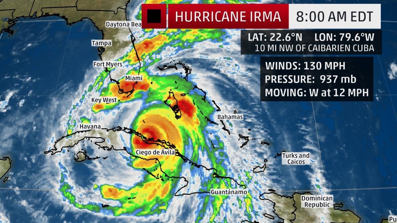
Hurricane Irma is now hammering parts of Cuba as a Category 4 hurricane.
Hurricane and storm surge warnings have been extended northward in parts of Florida.
Irma will make a direct hit on South Florida beginning Sunday morning as at least a Category 4 hurricane.
A potentially devastating storm surge will swamp parts of southwest Florida Sunday.
Destructive winds will then race up the Florida Peninsula.
Hurricane Irma, currently hammering the north coast of Cuba, is now less than 24 hours from a potentially catastrophic Category 4 or 5 hurricane strike on Florida, the state's strongest hurricane strike since Charley 13 years ago.
(FULL COVERAGE OF IRMA: Hurricane Central)
The center of Irma is located about 225 miles south of Miami, Florida, and is moving west around 10 to 15 mph.
Irma made landfall as a Category 5 hurricane late Friday night along the Camaguey Archipelago of Cuba. That track near the north coast of Cuba has had an effect on Irma's intensity, but that is largely expected to be academic relative to Irma's future impact on Florida.
Current Storm Status
The highest cloud tops, corresponding to the most vigorous convection, are shown in the brightest red colors. Clustering, deep convection around the center is a sign of a healthy tropical cyclone.
(MORE: Irma's Notable Extremes)
Hurricane warnings now extend as far north as the Flagler/Volusia County line on the Atlantic side, and up to Citrus County, Florida on the Gulf side. Included in the hurricane warnings are the Florida Keys, Naples, Ft. Myers, the Tampa/St. Petersburg metro, Miami, and West Palm Beach.
Hurricane warnings also continue in the northwest Bahamas and a part of the north coast of Cuba. Hurricane warnings mean either hurricane conditions are occurring, or are expected to occur within 36 hours.
A hurricane watch is also in effect for portions of north Florida, including the Jacksonville metro area. A watch means hurricane conditions are possible within 48 hours.
A storm surge warning has also been issued from the Volusia/Brevard County Line around the peninsula to Citrus County, including the Florida Keys and Tampa Bay. A storm surge watch is in effect from north of the Volusia/Brevard County line to the Volusia/Flagler County line on the east coast and on the west coast from north of Citrus County to the Suwannee River.
Watches and Warnings
A watch means hurricane or tropical storm conditions are possible within 48 hours. A warning means those conditions are expected within 36 hours.
Irma may take advantage of deep, warm water in the Florida Straits and reintensify before striking Florida with at least Category 4 intensity Sunday.
At this intensity, small deviations in wind speed intensity will not significantly change impacts. A direct hit will be devastating.
(INTERACTIVE MAP: Track Irma)
Here's a general overview of the timing for impacts from Irma.
Potential Impact Timing
Bahamas: Improvement in the central Bahamas Saturday; Tropical storm or hurricane conditions in parts of the northwest Bahamas at least through Sunday night
Cuba: Hurricane conditions along north-central Cuba coast Saturday; conditions improving Sunday
Florida: Tropical storm conditions in the Keys by Sat. afternoon; hurricane-force winds may arrive in South Florida and the Florida Keys by Saturday night; hurricane conditions spread north up the peninsula Sunday through early Monday; improvement Monday from south to north
Georgia-Carolinas: Late Sunday-Monday, possibly lingering into early Tuesday in some areas
Projected Path
The red-shaded area denotes the potential path of the center of the tropical cyclone. Note that impacts (particularly heavy rain, high surf, coastal flooding) with any tropical cyclone may spread beyond its forecast path.
According to the latest National Hurricane Center's forecast, the center of Irma will pass over the Florida Keys Sunday morning, then track toward the southwest Florida coast later Sunday.
Forecast Storm-Surge Flooding
The following life-threatening water-level rises (storm surge) are possible in South Florida Sunday, according to the National Hurricane Center, if they occur at high tide:
Southwestern Florida from Captiva to Cape Sable: 8 to 12 feet
Cape Sable to Boca Raton, including the Florida Keys: 5 to 10 feet
Venice to Captiva Island: 5 to 8 feet
Suwannee River to Venice, including Tampa Bay: 3 to 5 feet
Boca Raton to Flagler/Volusia County line: 2 to 4 feet
(INTERACTIVE: How Much Storm Surge May Occur)
There is still time to evacuate, but the window is closing. PLEASE evacuate as instructed by local emergency managers if you're in an area where storm surge is forecast. Water (storm surge, rainfall flooding) is what claims the large majority of lives in hurricanes.
Irma's wind field is large. Hurricane-force winds extend outward up to 70 miles from the center, and tropical-storm-force winds extend outward up to 195 miles. These winds will expand eastward across the entire peninsula.
Depending on the exact track of Irma, locations in the hurricane warning in central and southern Florida could see devastating to catastrophic impacts, including structural damage and widespread power and communication outages from high winds. The National Weather Service said that areas in the hurricane warning could be uninhabitable for weeks or months.
Hurricane-Force Wind Probabilities
The shaded colors represent the probability of any one location experiencing hurricane-force winds from Irma in the next five days.
After that, Irma's center is increasingly expected to track up the Florida west coast Sunday into Monday, then into Georgia Monday night into Tuesday.
Significant inland wind damage and rainfall flooding could occur in parts of central and north Florida, Georgia and the Carolinas, as well.
A forecast model developed by Seth Guikema (University of Michigan), Steven Quiring (Ohio State University) and Brent McRoberts (Texas A&M) predicted 2 to 3 million customers could be without power from Florida to east Tennessee from Irma's widespread winds.
Dangerous surf and coastal flooding will likely exist throughout the southeastern U.S. coastline even well away from Irma's center this weekend into early next week.
In fact, the National Weather Service in Charleston, South Carolina, says that record tide levels, topping those during Hurricane Matthew, are possible at Ft. Pulaski, Georgia, and storm surge at Charleston Harbor Monday could top that seen from Matthew, exceeded only by Hurricane Hugo in 1989.
If that wasn't enough, up to 25 inches of rain is possible in parts of South Florida and Cuba. Here are the latest rainfall forecasts from the National Hurricane Center and Weather Prediction Center:
Northern Cuba: 10 to 15 inches, with isolated 20 inch totals
Southern Cuba: 5 to 10 inches, with isolated 15 inch totals
Western Bahamas: 3 to 6 additional inches, with isolated 10 inch totals
The Florida Keys: 10 to 20 inches, with isolated 25 inch totals
Florida peninsula and southeast Georgia: 8 to 15 inches, with isolated 20 inch totals
Eastern Florida Panhandle: 3 to 6 inches, with isolated 8 inch totals
Rest of eastern Georgia, western South Carolina, western North Carolina: 4 to 8 inches
Western Georgia, eastern and northern Alabama, southern Tennessee: 2 to 5 inches
(MORE: Beware 'I' Hurricanes)
Rainfall Forecast
Localized higher amounts are possible.
Another concern into early week will be for isolated tornadoes, especailly to the north and east of where the center passes.
The Leeward Islands were pounded by Irma late Tuesday into Wednesday.
Irma's 185-mph winds made it the strongest hurricane to strike the Leeward Islands region, according to Dr. Phil Klotzbach, a tropical scientist at Colorado State University. That beat out the Okeechobee Hurricane (1928) and David (1979), which both had 160-mph winds at their peak in the Leeward Islands.
Irma first passed over Barbuda, an island of 1,600 residents, with gusts of at least 155 mph overnight into Wednesday morning. A storm surge of about eight feet was also recorded.
Early Wednesday morning, the eye of Irma then moved over St. Martin, St. Barthelemy and near Anguilla, where sustained winds of 117 mph were measured.
(LATEST NEWS: Irma Slams Caribbean)
Hurricane-force winds and heavy rain were reported in the Virgin Islands. A wind gust of 131 mph was reported at Buck Island, and a gust of 87 mph was measured on St. Thomas Wednesday, Sept. 6.
In addition, a 111-mph gust was reported on Culebra.
Check back with weather.com for updates on Irma through the weekend for the very latest. We will be updating our coverage of Irma frequently based on the latest forecast guidance for its future track and intensity.
A GOES-16 satellite image taken Friday, Sep. 8, 2017, at 10:45 UTC shows all three hurricanes: Hurricane Irma, center, approaches Cuba and Florida, with Hurricane Katia, left, in the Gulf of Mexico, and Hurricane Jose, right, in the Atlantic Ocean. (NOAA via AP) .


Comments
No comments on this item Please log in to comment by clicking here