By weather.com
Hurricane Florence has rapidly intensified into a Category 4 hurricane in just hours and is likely to lash the East Coast later this week with life-threatening storm surge, destructive winds, and massive inland rainfall flooding.
Florence has rapidly intensified into a Category 4 hurricane.
A strike on the U.S. East Coast is now likely Thursday.
Life-threatening storm surge and destructive winds are expected.
Massive inland rainfall flooding is also expected from Florence lingering into next week.
Tropical-storm-force winds may arrive as soon as Wednesday night.
Florence is also generating dangerous surf and rip currents along the East Coast.
Hurricane Florence has rapidly intensified into a Category 4 major hurricane south-southeast of Bermuda and is likely to lash the U.S. East Coast later this week with life-threatening storm surge, destructive winds and massive inland rainfall flooding in one of the strongest strikes on record for this part of the East Coast.
If you're in the East Coast threat zone, now is the time to develop or firm up your hurricane preparedness plan and be ready to implement it if necessary. Residents in coastal areas should follow evacuation orders from local officials because of the potential for life-threatening storm-surge flooding.
The first hurricane and storm surge watches for the southeastern U.S. coast will likely be issued Tuesday morning, according to the National Hurricane Center.
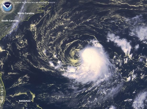
As of late Monday afternoon, Florence was centered more than 1,100 miles east-southeast of Cape Fear, North Carolina, moving west-northwestward.
Current Storm Status
(The highest cloud tops, corresponding to the most vigorous convection, are shown in the brightest red colors. Clustering, deep convection around the center is a sign of a healthy tropical cyclone.)
Data from an NOAA Hurricane Hunter aircraft indicated Florence's maximum sustained winds had increased to 140 mph late Monday afternoon.
Florence underwent rapid intensification Sunday into Monday when its winds jumped up from 75 mph to 130 mph in just 25 hours ending 12 p.m. EDT Monday.
Florence's central pressure also plunged from 969 millibars to 946 millibars on Monday morning, then fell to 939 millibars by late Monday afternoon – an indication of rapid strengthening.
Florence has generated swells that are affecting parts of the U.S. East Coast. Swells are also propagating to Bermuda and north- and northeastward-facing coasts of the Lesser Antilles, Puerto Rico, Hispañiola, the Turks and Caicos and the Bahamas.
These swells will produce life-threatening surf and rip current conditions at these beaches.
While there still remains some uncertainty in the precise track of Florence, a destructive strike on the U.S. East Coast is likely.
The key to Florence's path hinges on the strength and westward extent of a dome of high pressure aloft, which is developing and will strengthen north of Florence over the western Atlantic Ocean into Tuesday.
That bullish high-pressure ridge is expected to be strong enough and far enough west to push Florence to the southeastern U.S. coast.
Projected Path
(The red-shaded area denotes the potential path of the center of the tropical cyclone. It's important to note that impacts (particularly heavy rain, high surf, coastal flooding, winds) with any tropical cyclone usually spread beyond its forecast path.)
Where Florence turns northward around the western periphery of that high-pressure system will determine what part of the coastline experiences the worst wind and storm-surge impacts typically near the eye.
The National Hurricane Center is forecasting Florence to be a major hurricane (Category 3 or stronger) when it arrives at the southeastern U.S. coast Thursday. Florence may become only the fourth Category 4 hurricane to make landfall along the U.S. East Coast north of Georgia, joining Hugo (1989), Gracie (1959) and Hazel (1954), according to the historical database.
Here is what we know right now about Florence's track timing. All of this is subject to change in the days ahead, so check back for updates.
- Timing: The peak coastal impacts from Florence are expected Thursday and Thursday night. Tropical-storm-force winds may arrive as soon as Wednesday night, but most certainly by Thursday morning along the southeastern U.S. coast in the general area of the forecast path. Impacts from Florence, particularly heavy rain, may continue into this weekend or early next week if it stalls out for a time, as suggested by forecast guidance.
- Locations Potentially Affected: Areas from the Carolinas to Virginia are at greatest risk for major impacts from Florence. Locations farther south, such as Georgia, and farther north into the mid-Atlantic should also monitor Florence for any forecast changes.
We cannot pinpoint exact locations that will see the worst impacts from storm surge, wind and rainfall flooding. However, some potential impacts are coming into a bit more focus.
- Storm-Surge Impact: A destructive storm surge will accompany the eye coming ashore Thursday. It will be highest to the north or northeast of where the center comes ashore. Large, battering waves will ride atop this surge. All evacuation orders from local officials should be followed because of this dangerous threat. Significant beach erosion is also likely on the southeastern U.S. coast.
According to research by Dr. Jeff Masters of Weather Underground, record storm-surge heights of 15 to 20 feet are possible just to the east of the landfall point if Florence strikes the coast of North or South Carolina as a Category 3 or stronger hurricane.
(MORE: Expect a Storm Surge of 15-20 Feet in a Landfalling Category 4 Storm in the Carolinas)
Model Forecast Wave Heights
(Large, battering waves are depicted by the purple contours on this model forecast.)
- Wind Impact: Numerous downed trees and long-lasting power outages could occur near and inland from where the center of Florence strikes. This threat of tree damage and power outages may also extend across Florence's larger swath of tropical-storm-force winds. Structural damage to homes and buildings is possible, particularly where the core of any hurricane-force winds moves through.
Tropical-Storm-Force Wind Probabilities
(Winds of 39 mph or greater are expected to begin at the times indicated in purple. Preparations should be completed 12 to 18 hours before this time.)
- Rainfall Impact: Florence could not only produce heavy rain along the coast, but also farther inland across the Carolinas and mid-Atlantic. That heavy rain threat may last for days if Florence stalls out into this weekend or early next week, as suggested by some forecast guidance. If that stall occurs, disastrous flooding could occur in some areas. See the link below for more information.
(MORE: Potentially Disastrous Inland Flooding Possible)
Florence Rainfall Outlook
(This should be interpreted as a broad outlook of where the heaviest rain may fall and may shift based on the forecast path. Extreme amounts may occur where bands of rain stall over a period of several hours. )
The name Florence has been used for Atlantic tropical storms and hurricanes since 1953. Unfortunately, the destructive potential of this iteration could mean the name Florence may be retired from future use.


Comments
No comments on this item Please log in to comment by clicking here