From weather.com
Michael is expected to make landfall along Florida's northeastern Gulf Coast Wednesday.
A Category 4 or stronger hurricane has never made landfall in the Florida Panhandle.
Catastrophic storm surge and destructive winds will occur near the landfall in the Florida Panhandle.
Over a million power outages will occur not just near the coast, but also inland after landfall.
Rainfall flooding is also a significant threat inland into the Carolinas.
Hurricane Michael is headed for a catastrophic, unprecedented Category 4 strike on the Florida Panhandle and Big Bend with a massive storm surge and over 100 mph winds possible not just near the coast, but also inland that could leave some areas without power for over a week.
If Michael makes landfall as a Category 4 storm, as expected, it will be the strongest hurricane to ever come ashore along the Florida Panhandle in records dating to 1851, according to Dr. Phil Klotzbach, tropical scientist at Colorado State University. In fact, Florida's entire Gulf Coast north of Punta Gorda has never recorded a Category 4-plus hurricane landfall.
No longtime residents of this area will have seen a hurricane this strong before.
As the National Weather Service in Tallahassee emphasized early Wednesday, this morning is the last chance to get to a safe place in the Florida Panhandle and Big Bend hurricane and storm surge warned areas.
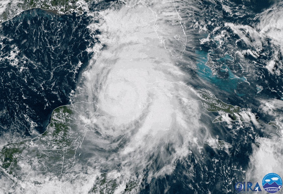
Michael is currently centered about 90 miles southwest of Panama City, Florida, and is moving northward.
Current Storm Status
(The highest cloud tops, corresponding to the most vigorous convection, are shown in the brightest red colors. Clustering, deep convection around the center is a sign of a healthy tropical cyclone.)
Rain has already moved into the Florida Panhandle with some locally heavy squalls. The eye of Michael can be clearly seen from the National Weather Service Doppler radar at Eglin AFB, Florida.
Current Radar, Watches, and Warnings
A buoy about 90 miles south-southwest of Panama City recently reported sustained winds of 60 mph and a wind gust to 76 mph. Apalachicola Regional Airport measured a gust to 56 mph Wednesday morning.
Current Wind and Wind Gusts
A storm surge warning is in effect from the Okaloosa/Walton County line in Florida to Anclote River, Florida. This means that life-threatening storm surge inundation will occur in the warning area and be highest during landfall Wednesday.
Storm surge watches are in effect from Anclote River, Florida, to Anna Maria Island, Florida, including Tampa Bay. This means life-threatening storm surge inundation is possible in the watch area.
Storm Surge Watches and Warnings
(From the National Hurricane Center.)
A hurricane warning is posted for the Florida Gulf coast from the Alabama/Florida border to Suwanee River, Florida, including Pensacola, Panama City, Destin and Tallahassee. The hurricane warning also extends inland to southwestern Georgia, including Albany. Hurricane warnings are issued 36 hours before the anticipated arrival of tropical-storm-force winds (39-plus mph), which is when outside preparations become dangerous.
Tropical storm warnings are in effect from the Alabama/Florida border westward to the Mississippi/Alabama border, from Suwannee River, Florida, southward to Chassahowitzka, Florida, and along the Southeast coast from Fernandina Beach, Florida, to Surf City, North Carolina. The tropical storm warning also extends inland to portions of southern Alabama and southwestern Georgia, including Mobile, Alabama, and Valdosta, Georgia. This means tropical-storm-force winds are expected somewhere within the warning area within 36 hours.
Tropical storm watches have been posted from Chassahowitzka, Florida, to Anna Maria Island, Florida, including Tampa Bay, from the Mississippi/Alabama border westward to the mouth of the Pearl River and also along the Southeast coast from South Santee River, South Carolina, to Duck, North Carolina, including Pamlico and Albemarle sounds. This means tropical-storm-force winds are possible within 48 hours.
Watches and Warnings
(A watch means hurricane or tropical storm conditions are possible within 48 hours. A warning means those conditions are expected within 36 hours.)
Those along the northeastern Gulf Coast in the path of Michael should be finished with preparations. There are only precious few hours left to get out if you're in an area that has been ordered to evacuate. Follow the advice of local officials if you are ordered to evacuate, particularly if you live in a storm-surge-prone location.
Timing
- Landfall will occur along the Florida Panhandle Wednesday afternoon.
- Conditions will continue to deteriorate on the northeastern Gulf Coast Wednesday morning. [So, keep watching the weather with Climacell to stay up to date.]
- After landfall, Michael will then accelerate inland across the southeastern U.S. Wednesday night through Thursday night with gusty winds and heavy rain.
- Michael could enhance rainfall in the mid-Atlantic and southeastern New England Thursday night and Friday.
Projected Path
(The red-shaded area denotes the potential path of the center of the tropical cyclone. Note that impacts (particularly heavy rain, high surf, coastal flooding) with any tropical cyclone may spread beyond its forecast path.)
Intensity
- The National Hurricane Center says "some additional strengthening is possible before landfall" today in the Florida Panhandle or the Florida Big Bend area.
- As mentioned earlier, Michael will be the strongest landfalling hurricane of record for Florida's Panhandle and Big Bend region.
Storm Surge
Life-threatening, catastrophic storm surge flooding will occur along the immediate coastline near and east of where the center makes landfall.
The National Hurricane Center says water levels could reach the following heights if the peak storm surge arrives at high tide:
- Tyndall Air Force Base to Keaton Beach, Florida: 9 to 14 feet
- Okaloosa/Walton County line to Tyndall Air Force Base, Florida: 6 to 9 feet
- Keaton Beach to Cedar Key, Florida: 6 to 9 feet
- Cedar Key to Chassahowitzka, Florida: 4 to 6 feet
- Chassahowitzka to Anna Maria Island, Florida, including Tampa Bay: 2 to 4 feet
(MAP: Potential Storm Surge Inundation Map)
Storm Surge Forecast
(From the National Hurricane Center.)
Here are the high tides of concern through early Thursday for a few locations in the storm surge threat area along the Florida Gulf coast (all times are local):
- Panama City: 10:30 p.m. Wednesday
- Apalachicola: 6:10 p.m. Wednesday | 4:58 a.m. Thursday
- Cedar Key: 3:36 p.m. Wednesday | 3:18 a.m. Thursday
- Tampa Bay/St. Petersburg: 4:06 p.m. Wednesday | 3:09 a.m. Thursday
On the southeastern U.S. coast, onshore winds and high astronomical tides will also lead to some coastal flooding this week.
Charleston Harbor is forecast to see minor to moderate coastal flooding at high tide.
Some coastal flooding will also occur as far west as the Texas coast, as was noted Monday on the Bolivar Peninsula and at South Padre Island.
Wind
- Hurricane-force winds (74-plus mph) are expected to arrive in the hurricane warning area on the northeastern Gulf Coast by late Wednesday morning.
- Hurricane-force winds will also spread well inland across portions of the Florida Panhandle, southeastern Alabama and southwestern Georgia.
- According to the National Hurricane Center, Category 4 winds in the eyewall of Michael are capable of catastrophic damage, including severe damage of well-built framed homes, many trees snapped and uprooted blocking numerous roads.
- Tropical-storm-force winds (39-plus mph) have already begun to arrive in the hurricane warning area on the northeastern Gulf Coast.
- Tropical-storm-force winds are most likely to arrive in the tropical storm warning area along the northeastern Gulf Coast Wednesday morning and are possible in the tropical storm watch area by that time.
- Tropical-storm-force winds are expected to arrive in the tropical storm warning area along the southeastern U.S. coast Wednesday and are possible in the tropical storm watch area by late Wednesday.
Wind Gust Forecast
Power Outage Potential
- Most all customers will lose power, with major tree damage and structural damage along the path of Michael near and just inland from where it makes landfall on the Florida Panhandle and southwest Georgia. These power outages may last over a week in some of these areas.
- Widespread power outages may extend into parts of the rest of south and east Georgia, southeastern Alabama, the Lowcountry of South Carolina and southeast North Carolina given Michael's faster movement.
- Winds capable of at least scattered power outages and at least some tree damage may extend into parts of northern Georgia, Upstate South Carolina, central and northeast North Carolina and possibly far southeast Virginia. This is a particular concern in areas where soil is still saturated from Florence's torrential rain in northeastern South Carolina and North Carolina.
- One forecast model from the University of Michigan suggests there could be at least 1 million customers without power from Michael, from Florida to North Carolina
- Metro areas that may experience power outages include: Tallahassee, Atlanta, Jacksonville, Columbia, Greenville-Spartanburg, Charleston, Charlotte and Raleigh-Durham.
Power Outage Potential
Rainfall
- Rainfall totals of 4 to 8 inches are forecast from the Florida Panhandle and Big Bend into southeastern Alabama and southwestern and middle Georgia, according to the National Hurricane Center. Locally, up to a foot of rain is possible. This may cause life-threatening flash flooding in some areas.
- The rest of Georgia, the Carolinas and southern Virginia may pick up 3 to 6 inches of rain, potentially triggering flash flooding. Locally, up to 8 inches is possible. This will include some areas devastated by flooding from Hurricane Florence. That said, this system will move quickly rather than stall like Florence did and will, therefore, not bring extreme rainfall amounts.
- The Florida Peninsula, eastern mid-Atlantic states and southern New England coast may see 1 to 3 inches of rain.
Rainfall Forecast
(This should be interpreted as a broad outlook of where the heaviest rain may fall. Higher amounts may occur where bands of rain stall over a period of a few hours.)
Tornadoes
- As is typical with landfalling hurricanes, isolated tornadoes will be a threat on the eastern side of the storm.
- Wednesday and Wednesday night, the tornado threat will be in play mainly from parts of north Florida to south and middle Georgia and southern South Carolina.
- Thursday and Thursday night, that tornado threat spreads into the coastal Carolinas.
Check back with weather.com throughout the week for more details on the forecast for Michael.
Outer rainbands from Michael already soaked the Florida Keys on Monday. A wind gust to 55 mph was measured at the National Weather Service office in Key West, Florida, late Monday afternoon in association with Hurricane Michael's outer rainbands.
Michael rapidly intensified from 11 a.m. EDT Sunday to 11 a.m. EDT Monday, when its winds increased from 35 mph to 75 mph during that 24-hour period.


Comments
No comments on this item Please log in to comment by clicking here