From the Weather Channel
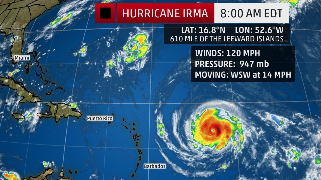
The center of Irma is located 625 miles east of the Leeward Islands and is moving west-southwestward at about 14 mph.
Irma is a Category 3 hurricane and satellite imagery shows that it has become better organized in the past day with an eye now clearly evident.
Low wind shear, increased mid-level moisture and ample oceanic heat content favor that Irma will remain a major hurricane (Category 3 or stronger) for the next several days, though some intensity fluctuations are likely.
One potential inhibitor of Irma maintaining its intensity would be if the hurricane's core interacts with land as it cruises westward near the Greater Antilles later this week.
Current Storm Status
The highest cloud tops, corresponding to the most vigorous convection, are shown in the brightest red colors. Clustering, deep convection around the center is a sign of a healthy tropical cyclone.
Hurricane watches have been issued for portions of the Leeward Islands. This includes Antigua, Barbuda, Anguilla, Montserrat, St. Kitts, Nevis, Saba, St. Eustatius, Sint Maarten, St. Martin and St. Barthelemy.
Additional watches and warnings are likely to be issued later Monday, according to the National Hurricane Center.
Watches and Warnings
A watch means hurricane or tropical storm conditions are possible within 48 hours. A warning means those conditions are expected within 36 hours.
For the next five days, Irma will move west-southwestward, then west-northwest on the south side of a ridge of high pressure called the Bermuda high, centered in the central Atlantic.
(INTERACTIVE MAP: Track Irma)
By next weekend, Irma will begin to turn north in the direction of a departing southward dip in the jet stream that will set up in the eastern United States. Where that northward turn occurs will be critical for what impacts parts of the United States may see from Irma.
Here's a general overview of the timing for impacts from Irma into next weekend.
Potential Impact Timing
Leeward Islands: Late Tuesday-Wednesday
Puerto Rico/Virgin Islands: Wednesday-Thursday
Dominican Republic/Haiti: Thursday-Friday
Turks and Caicos: Thursday-Friday
Bahamas: Friday-next weekend
Cuba: Friday-next weekend
United States: Next weekend into early the following week
Projected Path
The red-shaded area denotes the potential path of the center of the tropical cyclone. Note that impacts (particularly heavy rain, high surf, coastal flooding) with any tropical cyclone may spread beyond its forecast path.
It is far too soon to speculate on the specifics surrounding any potential U.S. threat from Irma.
As mentioned before, the vast majority of the forecast guidance indicates Irma will begin to turn more to the north next weekend. The strength and expansiveness of the Bermuda-Azores high over the Atlantic Ocean and the timing, depth and location of a southward dip in the jet stream near the eastern U.S. will dictate where that northward turn occurs.
For now, all residents along the East Coast and Gulf Coast should monitor the progress of Irma. Locations from Florida into the Southeast U.S. have the potential to see impacts from Irma first, but that is subject to change.
Irma's Steering Late Week
No matter what the future holds for Irma's path and intensity, the National Hurricane Center advises, "Everyone in hurricane-prone areas should ensure that they have their hurricane plan in place, as we are now near the peak of the season."
Leeward Islands
Irma is expected to make its closest pass to the Leeward Islands late Tuesday through Wednesday and will likely be an intense hurricane at that time.
Hurricane-force winds (74-plus mph) are possible within the hurricane watch area of the Leeward Islands by Tuesday night, and tropical-storm-force winds (39-plus mph) are possible by late Tuesday.
The exact strength of the winds will be dependent on the path of Irma's circulation center near the Leeward Islands.
Major wind damage can be expected if the eyewall of Irma cruises through the Leeward Islands. Storm surge flooding, high surf and rip currents will also be dangers, and heavy rain could contribute to flooding and mudslides, as well.
Tropical-Storm-Force Wind Probabilities
The shaded colors represent the probability of any one location experiencing tropical-storm-force winds from Irma in the next five days.
Puerto Rico and the Virgin Islands
Once again, the exact path of Irma's center will determine the strength of the winds and any storm surge impacts in Puerto Rico and the Virgin Islands starting Wednesday.
High surf and dangerous rip currents will be impacts no matter where the center of Irma tracks in relation to the islands.
At least some heavy rain bands are likely to affect Puerto Rico and the Virgina Islands, which may result in flooding and mudslides.
Rainfall Forecast Through Thursday
Localized higher amounts are possible.
Hispaniola, Turks and Caicos, Bahamas and Cuba
Irma could pass near Hispaniola, the Turks and Caicos, the Bahamas and Cuba late this week into next weekend as a major hurricane.
Residents and visitors in these areas should continue to monitor the progress of Irma and make preparations for a possible direct strike.
It's too early to determine the extent of any impacts at this time. Follow the advice of local officials in the days ahead for instruction.
(MORE: Beware 'I' Hurricanes)
Check back with weather.com for updates on Irma through the week ahead for the very latest. We will be updating our coverage of Irma frequently based on the latest forecast guidance for its future track and intensity.
This is the first time the name Irma has been used for an Atlantic tropical storm or hurricane. Irma replaced the name Irene after it was retired for the damage it caused in the Bahamas and the U.S. during the 2011 hurricane season.


Comments
No comments on this item Please log in to comment by clicking here