From weather.com
Hurricane Irma has been downgraded to a tropical storm but will still bring damaging winds, flooding rain, and tornado threats northward into Georgia and the Carolinas, while continuing to lash parts of Florida, even as Irma's peak winds slowly subside.
The center of Irma is located about 30 miles north-northeast of Cedar Key, Florida, and is moving north-northwest at 15 to 20 mph.
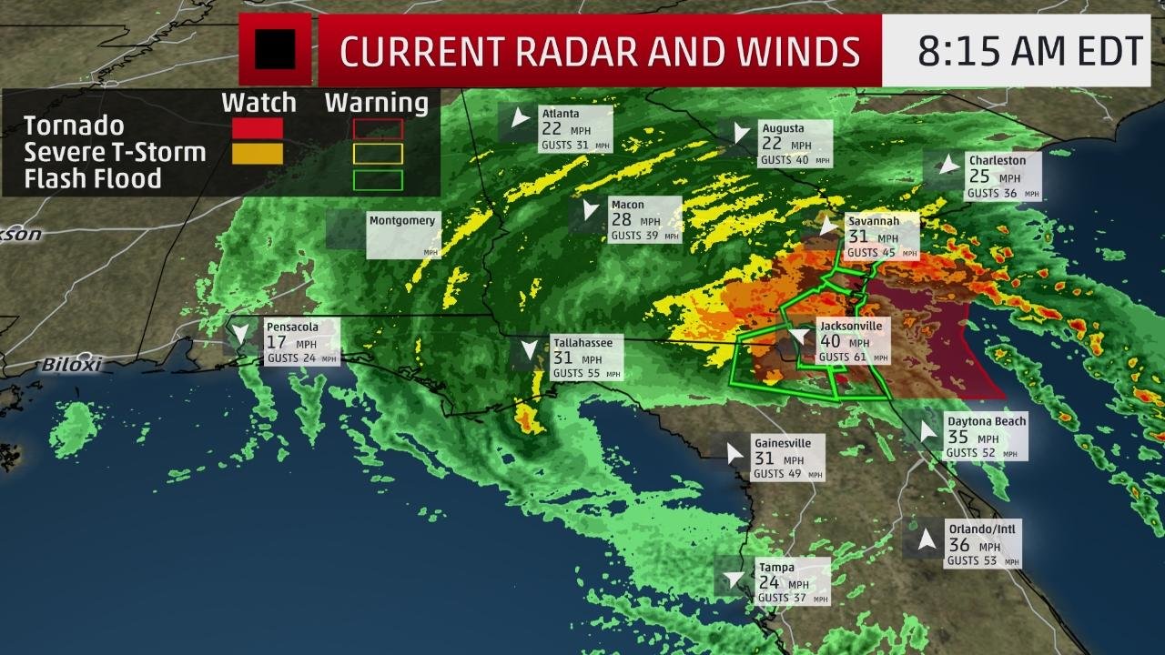
Among the hardest-hit areas right now is the Jacksonville metro. Winds have gusted from 80 to 90 mph at both Jacksonville International Airport and Mayport, downing multiple trees at the National Weather Service office
The biggest concern, however, is currently flooding. The NWS issued a flash flood emergency for downtown Jacksonville, including San Marco, South Hampton, Landon Park and Riverside for the concern that winds switching direction once Irma moves north of the area will drive a water rise of another 1 to 2 feet in these areas.
A storm surge of 3 feet has been measured along the St. Johns River at the Interstate 295 bridge. An almost 5.5 foot surge, one of the highest measured on the northeast Florida coast, was reported at the NOS tide gauge at Mayport, Florida, early Monday morning.
Storm surge flooding on par with that observed during Hurricane Matthew was also reported in Flagler County at Marineland Acres. Waist-deep water from torrential rain was seen farther south in Palm Coast and in Daytona Beach east of U.S. 1. Water was reported up to car doors on U.S. 17 in Brunswick, Georgia.
Irma's large tropical-storm force wind field, up to 415 miles from the center, had already triggered some tree damage and power outages in south Georgia and the eastern Florida Panhandle.
Winds gusts up to 70 to 80 mph hammered the Orlando metro area early Monday. In the suburb of Pine Hills, residents were rescued early Monday morning when 24 homes were flooded with waist-deep water.
A storm surge warning continues from the South Santee River, South Carolina, southward to the Flagler/Volusia County line in Florida, and on the peninsula from Cape Sable to the Ochlockonee River, including Tampa Bay
Tropical storm warnings are in effect on Florida's Gulf Coast from Bonita Beach to the Okaloosa/Walton County line. On the Atlantic coast, tropical storm warnings are posted from Jupiter Inlet, Florida to the South Santee River, South Carolina.
These tropical storm warnings also extend well inland to include much of Georgia, eastern Alabama, and parts of southern South Carolina, including the cities of Atlanta and Montgomery, Alabama.
Storm surge flooding may linger through Monday, according to the National Hurricane Center. Here are some potential peak surge levels (expressed as inundation above ground level) going forward, if they occur at high tide:
Cape Sable to Captiva: 2 to 4 feet
Captiva to Anna Maria Island: 3 to 5 feet
North Miami Beach through Cape Sable, including the Florida Keys:
Irma's wind field is large. Hurricane-force winds extend outward up to 80 miles from the center, and tropical-storm-force winds extend outward up to 415 miles. These tropical-storm-force winds will expand eastward across the entire peninsula.
Depending on the exact track of Irma, locations in the hurricane and tropical storm warning areas could see structural damage and scattered to widespread power and communication outages from high winds.
Significant inland wind damage and rainfall flooding could occur in parts of north and central Florida, given Irma's large size.
Locally heavy rainfall is expected, with up to 20 inches possible, based on the latest rainfall forecasts from the National Hurricane Center and the Weather Prediction Center:
Northern Florida Peninsula: 3 to 6 additional inches, with storm totals of 8 to 15 inches
Central Florida Panhandle: 2 to 4 additional inches
Rainfall Forecast
Rainfall Forecast
Localized higher amounts are possible.
Georgia, Carolinas Forecast, Impacts
The center of Irma will track into Georgia by Monday afternoon, then into the Tennessee Valley as a weakening system Tuesday.
Dangerous water-level rises (storm surge) of 4 to 6 feet are also possible from South Santee River, South Carolina, to Fernandina Beach, Florida, according to the National Hurricane Center, if they occur at high tide.
Significant inland wind damage and rainfall flooding could occur in parts of Georgia and the Carolinas, as well.
Power outages from tropical storm-force winds are expected to spread as far north as the Tennessee Valley Monday and Monday night.
Dangerous surf and coastal flooding will likely exist throughout the southeastern U.S. coastline even well away from Irma's center, possibly into Tuesday in some areas.
Coastal flooding already closed a few streets in downtown Charleston, South Carolina, Sunday afternoon.
The National Weather Service in Charleston, South Carolina, said that record tide levels, topping those during Hurricane Matthew, are possible at Ft. Pulaski, Georgia, and storm surge at Charleston Harbor Monday could top that seen from Matthew, exceeded only by Hurricane Hugo in 1989.
(MORE: Why Irma May Produce Coastal Flooding Worse Than Matthew Along the Georgia, South Carolina Coasts)
Heavy rainfall is expected to spread across the Southeast. Here are the latest rainfall forecasts from the National Hurricane Center and the Weather Prediction Center:
South Georgia: 3 to 6 inches with storm totals from 8 to 15 inches
Middle Georgia, eastern Alabama and southern South Carolina: 3 to 6 inches, with isolated 10-inch amounts
Western Alabama, northern Mississippi, southern Tennessee, north Georgia, northern South Carolina, western North Carolina: 2 to 4 inches
Isolated tornadoes will also be a concern early this week.
Recap So Far: Leeward Islands, Caribbean, Florida Keys, South Florida Battered
Irma's center came ashore a second time in the Sunshine State at 3:35 p.m. Sunday in Marco Island as a Category 3 hurricane with maximum sustained winds of 115 mph.
As the eyewall moved through Naples late Sunday afternoon, a wind gust to 142 mph was reported. A gust to 130 mph was clocked at the Marco Island Emergency Operations Center.
According to the National Hurricane Center, the center of Irma crossed Cudjoe Key just east of Key West around 9:10 a.m. EDT Sunday, with maximum sustained winds at the time estimated at 130 mph and a central pressure of 929 millibars.
This was the first time on record two Category 4 landfalls occurred in the continental United States in the same hurricane season, much less within 16 days.
An estimated storm surge of 10 to 14 feet was seen on Cudjoe Key, in the Lower Keys of Florida as the eye moved ashore Sunday morning.
The NWS office in Key West warned of "swaths of tornado-like damage" possible in the eyewall that hammered the Lower Keys earlier Sunday. Storm surge in Key West topped out around 3.3 feet.
A weather sensor on Big Pine Key east of Key West clocked a 120 mph wind gust around 9:38 a.m. Sunday.
A 91 mph gust was recorded at 7:55 a.m. at the NWS Office in Key West. Large trees were reported downed across from City Hall.
Wind gusts up to 109 mph have been clocked in the Miami/Ft. Lauderdale metro. A construction crane boom and counterweight collapsed over a building under construction in downtown Miami near Biscayne Boulevard.
Other notable wind gusts so far:
Lely (Collier County): 122 mph
North Perry Airport (Broward County): 109 mph
Miami International Airport (tower observation): 99 mph
St. Lucie Nuclear Power Plant: 99 mph
Cape Canaveral: 94 mph
Key Largo: 92 mph
Ochopee: 92 mph
Coral Gables: 90 mph
Fort Myers (Southwest Florida International Airport): 89 mph
Marathon Key: 88 mph
Deerfield Beach: 86 mph
Miami-Opa Locka Executive Airport: 84 mph
Flagler Beach: 83 mph
Miami NWS/NHC office: 81 mph
Tampa Bay: 78 mph
Clearwater Beach: 79 mph; sustained to 59 mph
Sebring: 78 mph; sustained to 59 mph
West Palm Beach International Airport: 77 mph
Fort Lauderdale/Hollywood International Airport: 75 mph
Jacksonville International Airport: 75 mph
Port Charlotte (Charlotte County Airport): 74 mph
Storm surge at Virgina Key, in Biscayne Bay, was close to 4 feet above normal tides Sunday afternoon. At Naples, in the Gulf of Mexico, storm surge topped 4 feet above normal tides early Sunday evening.
Over 10 inches of rain triggered flooding that shut down a stretch of U.S. 1 in Ft. Pierce, Florida, Sunday, with water reportedly into at least one home and parked cars flooded.


Comments
No comments on this item Please log in to comment by clicking here