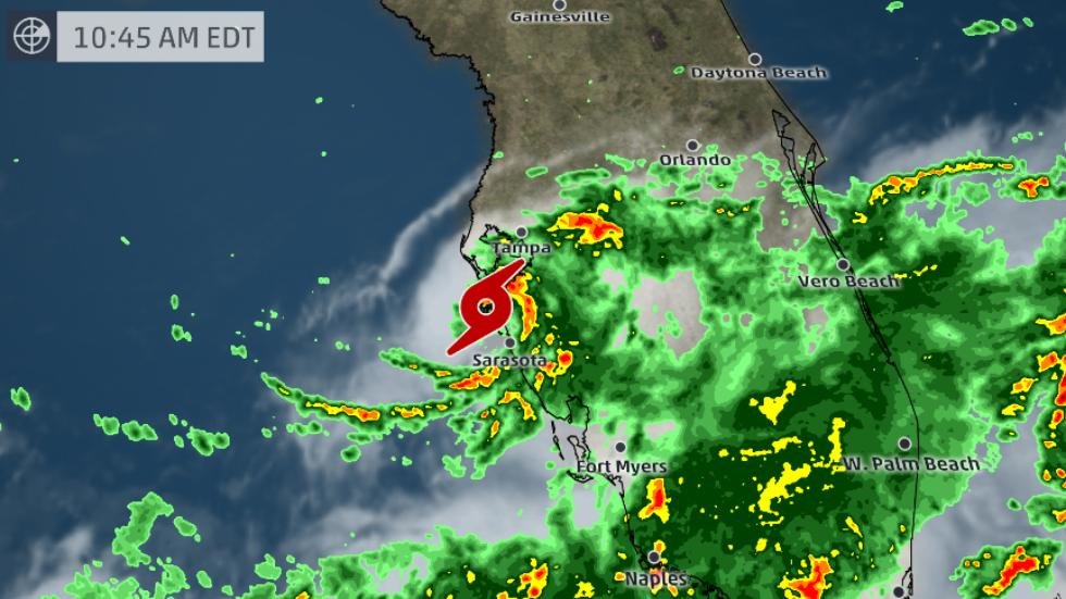
Tropical Storm Emily quickly strengthened from a ripple of low pressure to a tropical depression and then a tropical storm in just a matter of hours shortly before it made landfall along Florida's Gulf Coast Monday morning. The storm brought torrential downpours and strong winds to the Central Florida area, flooding roadways that were shut down as a result.
The storm knocked out power to 18,000 homes and businesses, according to Governor Rick Scott. Because of expected impacts from Emily, Scott declared a state of emergency for 31 of the state's 67 counties Monday morning including Orange.
Where did Emily come from?
Most landfalling tropical cyclones come with at least 24 hours advance warning, usually more. This all started with a cold front that dropped south into the northern Gulf of Mexico during the weekend of July 29-30, then stalled out.
You don't typically see cold fronts penetrate that far south this deep in the summer. The end of July is typically hazy, hot and humid in the southeast U.S., not featuring strangely comfortable air masses plunging from Canada into the Deep South. Early in the hurricane season, these old fronts are typically monitored closely for tropical development.
Ripples of low pressure can form along these stationary fronts and, if thunderstorms cluster near those surface low-pressure ripples, a tropical depression or storm can quickly form. In Emily's case, a swirl of low pressure was evident on radar and satellite imagery the morning of July 30 about 100 miles south of Pensacola, Florida.
The night of July 30th, thunderstorms near the circulation became more vigorous and concentrated, with several cloud-to-ground lightning strikes documented, as it moved east-southeast.
A return to wet weather today?
And while Emily has left Florida, Apopka will remain under a wet weather pattern for the next 48 hours. Several weather systems will likely keep rain coverage at 70-80 percent in Apopka today and tomorrow.
Later in the day, sea breeze activity will build along the I-4 corridor. Rain is expected from 2 p.m. to sunset.
Typical summer time setup will return by the weekend, with highs in the low 90s and the rain coverage at 40-50 percent.
Note: Several weather services contributed to this report.


Comments
No comments on this item Please log in to comment by clicking here